Do you know what is a green way? They are disused train tracks that have been converted into cycle itineraries and hikers for the enjoyment of people.
In Goierri we have the Mutiloa-Ormaiztegi greenway.
The Green Road is another good hike for families. It has a didactic game of a route that combines orienteering, hiking and a lot of fun.
This route is a circular trail, also suitable for the Nordic walking technique.
To complete the game, you need to answer questions about the 10 marks in the circuit correctly. The questions are about nature, the environment, and mining.
Come with your family and enjoy a pleasant walk enlivened by a nice game to have fun with family!
Tou and your kids will get the map and a pencil from the tourist office in Ormaiztegi, which is inside the Zumalacárregui Museum. If you preffer, you can download it from our website.
Leave Altzagarate and head to Zaldibia on your way to Gaintza, not taking A-1.
On your way up you will see a first shot of mount Txindoki! If you leave your car in Gaintza’s square, it might be a good plan to walk back just to enjoy those views more carefully.
From here, head to Lazkao’s exit, taking A-1. After one kilometre, take the roundabout to Lazkaomendi. The neighbourhood of Lazkaomendi shows a breathtaking view of Txindoki and Aralar natural park. Head down to Lazkao again and take the road to the next point, known as Goierri’s balcony: Olaberria.
Lazkaomendi – mount Txindoki & Aralar Nature Park
Here you get views of both natural parks of Aizkorri-Aratz and Aralar. The monolith that indicates is located in one of the sides of San Juan Bautista’s church.
Next stop is Zerain. To get to this town, get back on A-1 towards Vitoria-Gasteiz, taking the exit Idiazabal-Segura. Leave your car in the square where the Ostatu is, and then enjoy the views in Segura, Idiazabal peaks, mounts Usurbe, Txindoki, Aizkorri…and enjoy the town itself: its ethnographic museum, the hydraulic sawmill, a craft, and all the landscape shaped by the mining industry.
Go back the same way and when you see Otatza cider house in Zerain, leave the car and walk 50 m towards Barbaris. You will reach a point from where you get a unique view of Segura, and its very well preserved medieval quarter. Crossing the town of Segura, get the path to Mutiloa and go up to the neighbourhood of Liernia.
Olaberria
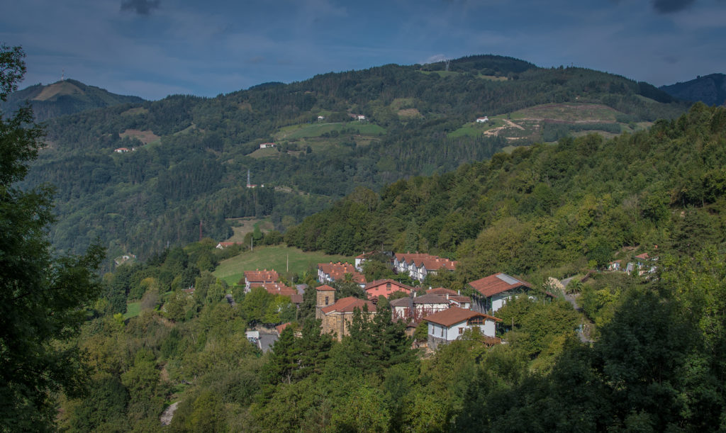
Head to Gabiria, last stage of this route, following the signals at the exit of Liernia. In Gabiria you will find a small rural village located on a hill, all peace and quiet, offering a very nice view of the region.
If you still want to continue drving and visitng the highest areas of Goierri, you can access to Mount Usurbe, a mountain characteristic of the town of Beasain. You can leave the car in the car parking located a little below the top and in a pleasant 10 minute walk you will reach the top of the mountain and the viewpoint.
Views from Usurbe
how to get there
Explore other plans
in Goierri
Explore other plans
in Goierri
WE’LL HELP YOU PLAN
your trip
Fill out the form and let us know your preferences.
In Aizkorri-Aratz, two areas can be distinguished, according to their landscape and geology: the sharp limestone ridge with grass lowlands in the valley (Urbia) and the concatenation of hills and the siliceous mountain pass completely covered with varied vegetation, leaving the rock out of sight.
The summits of the latter were the location chosen to open the first wind energy industrial estate in the Autonomous Basque Community. The treeless area increases the widespread livestock. The grass in the high mountains is always full of thousands of sheep that graze on them from the beginning of spring to the late autumn. Many species of birds of prey (peregrine falcon, griffon vulture, booted eagle…) and other forest and mountain birds fly over, while amphibians like the alpine newt populate streams and ponds in the high mountain. As for mammals, you can find wild cats and the pine marten, which are in danger of extinction.
Aralar
Aralar mountain range offers an impressive layout with limestone elevations, rivers and natural springs. It presents a rich flora and interesting fauna: griffon vulture, golden eagle and bearded vulture. Horses, cows and sheep populate their fields, a very common spot to see the latxa sheep -producers of the delicious milk that turns into the famous Idiazabal cheese– grazing in the core of the massif.
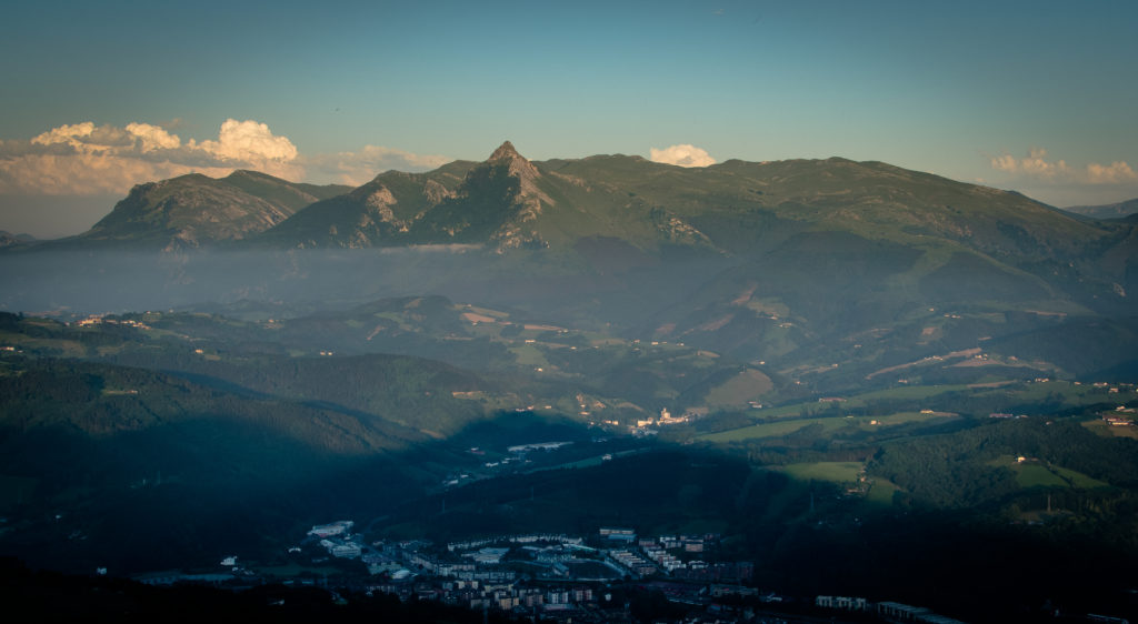
The most iconic peak is Txindoki, also known as Larrunari and Ñañarri. It is the most loved mountain in Guipúzcoa. You can spot its elegant silhouette from many points of the region! Get into the park through two entrances: Abaltzisketa or Ataun. Beech trees cover a quarter of its total area, 10,971 hectares, making it the biggest beech forest in Guipúzcoa, a true pride in our natural heritage. At the top of Lizarrusti (Ataun) you will find Aralar’s Natural Park Interpretation Centre, where there’s a permanent exhibition as well as information about the park and its surrounding areas.
If you’re all about archaeological heritage, the megalithic wealth visible in Aralar will surprise you: the biggest concentration of megalithic monuments in the Basque Country is right here in Aralar, demonstrating the significance that prehistoric Basques gave to their pasturelands. In the megalithic station of Aralar they found the first dolmen in Guipúzcoa and the first diggings in Euskal Herria also took place in this site.
You will see dolmens, menhirs, monoliths and cromlechs. The long and short hikes are marked up for you to enjoy. In the port of Lizarrusti (Ataun) you will find an information point, a restaurant and a mountain hut.
Do you dare climb the mountain where Edurne Pasaban started practicing? The first woman to complete the ascent of the 14 eight-thousanders on Earth developed her hobby here, in the mountains of Goierri. The Aizkorri and Txindoki peaks give visitors the unique chance to enjoy nature, fresh air, and amazing landscapes, hence why she chose them as her regular training place.
It will take you about two hours to get to the top of Aizkorri. We recommend doing it in the morning, after visiting the Interpretation Centre of Aizkorri-Aratz Natural Park in Zegama. They’re lovely people who will help you out! You can download the routes and carry them on your GPS device. They will provide any needed map or explanation. For example, they will tell you the two ways of getting to the top of Aizkorri: from the port of Otzaurte and from San Adrián’s tunnel. The most direct way, also the best sign-posted, is departing from Sancti Spiritu’s Hermitage and the Mikeletes house. Before passing the tunnel, you need to follow the yellow signs and in less than two hours you will be at the top of Aizkorri. The drop is between 1000-1500 metres.
The second way to ascend the highest peak in Euskadi is to leave behind San Adrián’s tunnel and following the path at your right: a road with yellow and white signposts (the official colours for the short route).In summer, climbing to Aizkorri and seeing the amazing views and the sunset is just a fantastic plan. You can stay at the hut, but keep in mind that it is just an open space with concrete floor -no beds or facilities-, so you will need to bring your own sleeping bag and mat. It fits 6-8 people. We will share HIKING with you on a tour where we will climb the first indicated option (yellow spots) and lower the second option (white and yellow marks).
You can get to the tunnel by car and walk the last 20 minutes or take a 2 hours circular route by foot, which is very beautiful and well sign-posted. Zegama and Aizkorri-Aratz Natural Park will be your North star. Just keep in mind these simple directions: If you’re coming to Goierri through the port of Etzegarate, take the first turn on the road to get into Zegama, instead of getting in through the town centre.
In five minutes you will reach the top of Otzaurte and in front of the Otzaurteko Benta Restaurant (gorgeous your beans!) You must continue on a concrete track about 10 minutes by car until you find a parking enabled, parking lot of Aldaola, large and with gravel.
The parking area in Aldaola has plenty of signs to explain the hiking trail. At the beginning, you will cross the small channel of water and keep going up the mountain towards Casa de los Mikeletes -an old construction for taxes collection and goods control-. When you get there you willstart to see the tunnel and the mountains. Go through the tunnel! Inside there’s an old hermitage and the remains of other old constructions.
The route continues following the green and white marks. Stay on that path and to get to San Adrián’s balcony… amazing views are waiting for you! This is one of the best viewpoints in Aizkorri-Aratz Natural Park. You will see the tunnel from the opposite side and Guipúzcoa and Navarre’s orography.
Connecting Europe to the Cantabrian Sea
You are in a magic place known by the ancients as the hole to hell, where significant evidence of prehistoric settlements was found, and not just burial sites. From the Bronze Age to the Middle Ages, San Adrián was one of the entrances to the mountain chain. When Guipúzcoa and Álava became part of the Crown of Castile, San Adrián was the mandatory route connecting Europe and the Cantabrian Sea. There was even a castle that guarded the border to Navarra. San Adrián was the scene of many clashes and an area frequented by bandits. The citadel was abandoned when Castilla was annexed to Navarra in 1512. The stone path you will see looks Roman, and it’s popularly known as Calzada Romana (Roman Road), but it’s actually from the Middle Ages and it was the “Royal Path of Relay”.
[…] We crossed the Pyrenees through San Adrián’s port, and both the ascent and the descent were rough, full of stones and mud…– Andrea Navagiero, Ambassador of Venice in the Court of Madrid, 16th century.
San Adrián became a famous legend, feared in the whole world. Travelers would describe it as a daunting place: cliffs edges, trees beaten by the wind, caves that were the shelter of muggers, isolated spots.
Latxa sheep are native to Euskal Herria -Navarra and the Basque Country-. There are two varieties: dark-faced and blonde, and they are small to medium sized, as well as thin and agile. They need to be in good shape to go up the mountain and get the fresh grass that grows there. When winter comes, they seek shelter in any of the 30 barns in Goierri. The milk they produce is known for its richness, fruitiness and aroma. Only the milk from Latxa and Carranzana (breed from Biscay) is used to produced the high quality Idiazabal cheese in the Basque Country and Navarre for 8,000 years. Idiazabal Cheese has its own designation of origin. It is the local cheese of the region, Goierri, but Idiazabal is the village with the oldest known memories of the cheese. Shepherds have been making this cheese and receiving awards not only in Spain but internationally, as a very well-loved and unique product.
Among two natural parks Each latxa sheep produces a reduced volume of milk but their milk is of great quality: 120 litres each season, only from March to July. Sometimes they’ll make 210 litres. From their raw milk we can make Idiazabal cheese. To get that particular flavour, shepherds and flocks follow the traditional routes determined by seasons: pastureland in spring, summer and autumn, and valleys during winter. Those pastures will be a defining feature on the taste and flavour of the milk.
From the sheep we also get Zaldibia’s mondeju, an artisan sausage made in caseríos during September and October. You will enjoy this cheese even more when you are familiar with its traditional fabrication process: by hand. It comes from the milk of latxa sheep, yes, but it also comes from fields, pastures, meadows, and the hands of shepherds.
These all kept alive the recipe of this cheese traditionally made so that we can enjoy it today. The location of Idiazabal, between the Natural Parks of Aizkorri-Aratz and Aralar, is key to this process. Only by visiting Goierri and Idiazabal will you learn everything about this cheese. You may also learn some recipes to cook with it and give this extra delicious taste to any of your meals! In the centre of the town, next to the church, you will see the Shepherd’s Monument, and a verse inscribed reads the necessary elements in grazing: the shepherd dog, the sheep, and the kaiku -container to collect the milk-. Latxa sheeps are also honoured in Idiazabal: you can find a ceramic sculpture of them in Gernika Tree square, next to a cutting of this very famous tree -very special for the Basques!- planted right there!
Know the product and the process of making Idiazabal cheeseThe cheese tasting and Interpretation Centre is the place where you should go to get info, try the cheese, or visit a dairy. There are guided tours, like Ondramuño Cheese House where the Aranburu family in charge of the business will explain how they make cheese everyday. If you go to Gaztañaditxulo Cheese House, you will see the actual work of the shepherd dog, feed the lambs, see how they behave… and after all this, you will be ready to try some delicious cheese and natural cider!
At Ondarre Cheese House in Segura, the family Goiburu has been working for more than 500 years and they can sure tell you what this is all about, as well as show you the stable, the milking parlour and the cheese-making room. Their cheese won the first prize in the annual Championship of Idiazabal Cheese in 2012, held in Ordizia, and it was sold in the next auction for 13,050€… half a cheese! Come visit and start experiencing Goierri!